Understanding the spatial distribution of river/stream and lake habitat types defined in the UK BAP list of priority habitats is needed to help ensure sufficient conservation action is targeted at them. Owing to the many pressures acting on our freshwater habitats, most examples of these habitat types do not feature on the priority habitat maps (which capture our most naturally functioning rivers, streams and lakes). However, allocating sites to habitat types included in the UK definitions of priority habitats highlights their conservation importance and adds weight to their protection and restoration, providing momentum for restoring higher levels of natural function in the habitat resource of each type.
Natural England is working with the Environment Agency and other partners to evaluate and report on the condition of these different types, as part of new processes for assessing the freshwater habitat resource. There are well-established national maps of lake types available from the GB lakes inventory. New maps of the distribution of river/stream types included in the UK BAP definition of priority river habitat are being developed and can be viewed on the Display data facility.
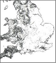
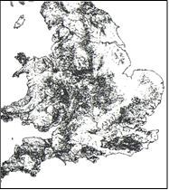
- A UK-level modelling exercise has generated provisional predictive maps of most types included in UK definition of priority river habitat, as well as other river and stream types relevant to the European Red List of Habitats. A progress report on this work is
Predicted distribution of European Red List type C2.2a (high energy) available here.
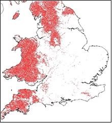
- Separate mapping work on chalk streams/rivers has been on-going with the Environment Agency and chalkstream stakeholders for some time. An explanation of how the current version of the map was produced can be found here and a downloadable version of the GIS layer is available from Natural England’s open data facility here.
Feedback on the local accuracy of these different maps can be provided through the Data Portal.